Today is Tuesday. I have to go in tomorrow to see what is happening with the Memphis IOOV Training.
The no cell phone stuff is killing me. I have to start making soure that I go in at least every other day to check for messages. There seems to be no rhyme or reason to the problem. If I do go in, I have to pick a good area or the messages don't drop in. then when I hit a good area, they all drop in.
Because I have to go in tomorrow, I am going to go sightseeing today so that I can see some of the stuff that I haven't gotten to yet. One of the locals told me that it will start getting warm in about 15-19 days. Maybe I can figure out how to get to Tupelo yet.
This is a picure of the Rocky Springs Picnic Area. It is a really nice area and depending upon where you park, there is the possibility of flush toilets nearby. the campgrounds are just as nice. There are no hook-ups but it is beautiful. I am told that the only times the campgrounds are busy are during the spring and fall. At all other times people seem to feel that it is either too hot or too cold. I can especially see the rationale behind the too hot.
So if you want to ride the Trace, it seems that either the spring or fall would be best.

This sign marks the foot path to Owens Creek. Down at the bottom of the post you will see Owens Creek and the other sign. This sign is part of the picnic area.
This is another part of the picnic area.

This is a sign that you see on the way up to the Old Rocky Springs Townsite. When I stand on the Old Natchez Trace, it is like the souls of the people who travelled before me are hanging around. I can't get over it. It just blows me away. it's like I can feel them.

This part of the trail is closed which I find really sad. The problems that they have here with soil erosion are massive. Soil erosion is rampant everywhere.

I took a few moments to walk down the path a bit. Here are a few pics of the trail, sxome of the erosion that has taken place and what the trail looks like in this part, really different from the "sunken" part of the Trace I was on Sunday.
The no cell phone stuff is killing me. I have to start making soure that I go in at least every other day to check for messages. There seems to be no rhyme or reason to the problem. If I do go in, I have to pick a good area or the messages don't drop in. then when I hit a good area, they all drop in.
Because I have to go in tomorrow, I am going to go sightseeing today so that I can see some of the stuff that I haven't gotten to yet. One of the locals told me that it will start getting warm in about 15-19 days. Maybe I can figure out how to get to Tupelo yet.
This is a picure of the Rocky Springs Picnic Area. It is a really nice area and depending upon where you park, there is the possibility of flush toilets nearby. the campgrounds are just as nice. There are no hook-ups but it is beautiful. I am told that the only times the campgrounds are busy are during the spring and fall. At all other times people seem to feel that it is either too hot or too cold. I can especially see the rationale behind the too hot.
So if you want to ride the Trace, it seems that either the spring or fall would be best.
This sign marks the foot path to Owens Creek. Down at the bottom of the post you will see Owens Creek and the other sign. This sign is part of the picnic area.
This is another part of the picnic area.
This is a sign that you see on the way up to the Old Rocky Springs Townsite. When I stand on the Old Natchez Trace, it is like the souls of the people who travelled before me are hanging around. I can't get over it. It just blows me away. it's like I can feel them.
This part of the trail is closed which I find really sad. The problems that they have here with soil erosion are massive. Soil erosion is rampant everywhere.
I took a few moments to walk down the path a bit. Here are a few pics of the trail, sxome of the erosion that has taken place and what the trail looks like in this part, really different from the "sunken" part of the Trace I was on Sunday.
Here is a sample of where the side of the trail is eroding away. Part of the reason the erosion is happening more rapidly is due to the amount of people who use the trails.

Here is a pic of the Old Trace.

It is just the most beautiful area. I love the trails so much and wish that I were more mobile to be able to use them more. I hope to be able to do some as I start to lose more weight.
Another view. I just feel regenerated and renewed by being among the trees and the grasses.
 The road leading up to Rocky Springs and the Rocky Springs Methodist Church. This section is a one way road.

This sign tells more about the Rocky Springs Townsite and Church area. It somewhat bothers me that there aren't more definitive answers in places that have been researched. Many of the posts are speculative that are on the signs. I like to know more in facts and figures.

This sign says: The Town of Rocky Springs At he end of this trail is evidence of a once thriving rural community. First settled in the late 1790's the town grew from a waterin place along the Natchez Trace and took its name from the source of that water--the rocky spring. In 1860, a total of 2,616 people lived in this area covering about 25 square miles. The population of the town proper included 3 merchants, 4 physicians, 4 teachers, 3 clergy adn 13 artisans, while the surrounding farming community included 54 planters, 20 overseers, and over 2,000 slaves who nurtured the crop that made the town possible--cotton.


 Next I cruised my bike over to Owens Creek.
This sign is a little harder to read. Here is what it says: Owens Creek. The sounds of a busy woodland stram and teh quiet murmur of a lazy waterfall have long been stilled here. Only after heavy rainfall does water fill the stream and set the waterfall singing.

I can tell you that the waterfall was definitely running as you can see in the following pictures.
Here is a pic of the Old Trace.
It is just the most beautiful area. I love the trails so much and wish that I were more mobile to be able to use them more. I hope to be able to do some as I start to lose more weight.
Another view. I just feel regenerated and renewed by being among the trees and the grasses.
The road leading up to Rocky Springs and the Rocky Springs Methodist Church. This section is a one way road.This sign tells more about the Rocky Springs Townsite and Church area. It somewhat bothers me that there aren't more definitive answers in places that have been researched. Many of the posts are speculative that are on the signs. I like to know more in facts and figures.
This sign says: The Town of Rocky Springs At he end of this trail is evidence of a once thriving rural community. First settled in the late 1790's the town grew from a waterin place along the Natchez Trace and took its name from the source of that water--the rocky spring. In 1860, a total of 2,616 people lived in this area covering about 25 square miles. The population of the town proper included 3 merchants, 4 physicians, 4 teachers, 3 clergy adn 13 artisans, while the surrounding farming community included 54 planters, 20 overseers, and over 2,000 slaves who nurtured the crop that made the town possible--cotton.
Most of the follwoing signs are extrememly readable and can be read on their own through the miracle of modern photography. Thus saving my fingers from typing everything in. ;-)

 Above is the trail that leads up to the old town and Rocky Springs Methodist Church. Along the trail there are several signs that tell part of the story as to why Rocky Springs is no longer in existence.


This is a shot of the Rocky Springs Church that shows the loess soil and part of the erosion problems that are going on. The problem is so bad that unless the erosion is stopped or slowed then it will undermine the buildings. When Katrina went through what happened is that 70 to 80 mile and hour winds hit as far north as Jackson, MS. That is amount of wind is enough to rearrange a lot of soil.
I find it interesting that this sign mentions that the slaves were carried away, not that they were released. I can better understand that the horses and mules were pressed into service, but wonder about the wording regarding that the slaves were carried away. What does that mean?


Above is a distance sight of the path around the old part of Rocky Springs town.

Yellow fever was considered a true plague. Three other examples of plagues are dysentery, cholera and smallpox. Yelolow fever struck many areas of the country and took thousands of lives. The statement that only God can see it all for our good is interesting.
Above is the trail that leads up to the old town and Rocky Springs Methodist Church. Along the trail there are several signs that tell part of the story as to why Rocky Springs is no longer in existence.This sign talks about the erosion that I mentioned earlier. Much of the soil in these parts is loess with is very fine. Because the soil is so fine it blows away or when it rains it will run down the side of the slopes or hills.
This is a shot of the Rocky Springs Church that shows the loess soil and part of the erosion problems that are going on. The problem is so bad that unless the erosion is stopped or slowed then it will undermine the buildings. When Katrina went through what happened is that 70 to 80 mile and hour winds hit as far north as Jackson, MS. That is amount of wind is enough to rearrange a lot of soil.
I find it interesting that this sign mentions that the slaves were carried away, not that they were released. I can better understand that the horses and mules were pressed into service, but wonder about the wording regarding that the slaves were carried away. What does that mean?
Above is a distance sight of the path around the old part of Rocky Springs town.
Yellow fever was considered a true plague. Three other examples of plagues are dysentery, cholera and smallpox. Yelolow fever struck many areas of the country and took thousands of lives. The statement that only God can see it all for our good is interesting.
Yellow fever is causes chills, fever, hemoraging and a jaundiced, yellow color--hence the name yellow fever.

The sign telling us where to go to see either the church or the town. Since you are travelling my blog, we are going to visit the town first. To get to the town we have to cross this little bridge.
 Interesting sign. There are people who live in the 25 mile area, but none who live in what was considered the town proper.

The following sign says: "This church was built in 1837 by the Methodist congregation of Rocky Springs. Earlier the town had been a station for a circuit-riding preacher who stopped by only once or twice a month. The church is preserved by the former congregation members who hold regular services here and gather here for an annual "homecoming" each spring."

To see the inside of the church, you will have to go see it for yourself. The pics I took didn't turn out well.
The sign telling us where to go to see either the church or the town. Since you are travelling my blog, we are going to visit the town first.
To get to the town we have to cross this little bridge. Interesting sign. There are people who live in the 25 mile area, but none who live in what was considered the town proper.Below is a shot through trees to an old safe. Two safes remain in the town, while another safe has been removed and is in the Rocky Springs Visitors Center that is near the campground.

A shot across the road to a unique soil erosion process.

The building foundation remains really don't look like a ginhouse building to me. (And yes, I have looked at building remains my whole life and done some excavating.) grin
Hmmm, really , really, doesn't look much like a building foundation to me, especially a cotton gin. I guess as an excavator, I really like facts and figures.

Now the cistern really does look like a cistern. ;)


I had a couple of people ask me what a cistern is. Walton Feed has instructions on how to make a cistern. And Wikipedia has some explanations as to why they are not used as much in the United States any more.


Rocky Springs Methodist Church


The church is open. You can't drive in the parking lot from the highway but you can access the church from the hiking trail. The church services are fairly early in the mornings (around 8AM) and as usual, I couldn't make it up that early, but I did think about it.
A shot across the road to a unique soil erosion process.
The building foundation remains really don't look like a ginhouse building to me. (And yes, I have looked at building remains my whole life and done some excavating.) grin
Hmmm, really , really, doesn't look much like a building foundation to me, especially a cotton gin. I guess as an excavator, I really like facts and figures.
Now the cistern really does look like a cistern. ;)
And the safe looks like a safe. The sides are not just metal, but filled with a heavy rock.
I had a couple of people ask me what a cistern is. Walton Feed has instructions on how to make a cistern. And Wikipedia has some explanations as to why they are not used as much in the United States any more.
Rocky Springs Methodist Church
The church is open. You can't drive in the parking lot from the highway but you can access the church from the hiking trail. The church services are fairly early in the mornings (around 8AM) and as usual, I couldn't make it up that early, but I did think about it.
The methodist churches in rural communities when the churches are small often are what are called "point charges". A point charge is where the pastor may have two or three churches and drives to all of them to give a sermon on any given Sunday morning. (As in the pastor has to drive from point to point.) Depending upon how far apart the churches are a lay leader, (a congregant who often has taken special classes) may start or end the service as the pastor may need to leave to get to the other church.
In some two and three point charges, a main way to get together with the pastor and other congregants at the same time is a pot luck dinner. (At least that has been my experience.)
There is a donation jar in the sanctuary.
The following sign says: "This church was built in 1837 by the Methodist congregation of Rocky Springs. Earlier the town had been a station for a circuit-riding preacher who stopped by only once or twice a month. The church is preserved by the former congregation members who hold regular services here and gather here for an annual "homecoming" each spring."
To see the inside of the church, you will have to go see it for yourself. The pics I took didn't turn out well.
Following is a shot of the church cemetary.
Next I cruised my bike over to Owens Creek.This sign is a little harder to read. Here is what it says: Owens Creek. The sounds of a busy woodland stram and teh quiet murmur of a lazy waterfall have long been stilled here. Only after heavy rainfall does water fill the stream and set the waterfall singing.
Over the years the water table has dropped several feet, adn the spring which feeds Owens Creek has all but disappeared.
Little remains of a scenic area once familar to early residents of the Rocky Springs Community.
I can tell you that the waterfall was definitely running as you can see in the following pictures.
Here is the sign that says the campground/picnic area is 2.5 miles. Remember that I showed you the other one at the beginning of this post?


Great path with the stepping stones, huh?


 Another path. Not used much now since it is covered in leaves. I don't know if it is used more in summer or not. I really have to work to scare up a ranger in the Rocky Springs Area. At Jeff Busby, we saw rangers all the time.


Happy Trails, Marty
Great path with the stepping stones, huh?
I think it is a cute little waterfall that would have been neat to have played in and cooled off in. (I guess now we would to to a water park.) I think this option is much more scenic.
Another path. Not used much now since it is covered in leaves. I don't know if it is used more in summer or not. I really have to work to scare up a ranger in the Rocky Springs Area. At Jeff Busby, we saw rangers all the time.It looks like the path used to be and go across here prior. I was wondering if erosion played a part in moving the path.
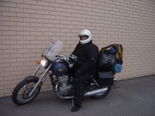
Here's my bike at Rocky Springs.
Happy Trails, Marty


No comments:
Post a Comment